Block or regulate artificial drainage paths.
01 / TECHNICAL BRIEF
THE CARBON RESERVOIR UNDERFOOT
Peatlands keep carbon underground. Water makes that possible.
CARBON2GREEN / HSP
Peat is not simply soil. It is an archive of partly decomposed vegetation accumulated where saturation slows decay. Restoration therefore begins with hydrology—not with a carbon claim.
WHY PEAT
Three percent of land.
Twice the carbon of the world's forests.
That disproportion is what makes peatlands globally important. In a healthy system, plant material enters a saturated, oxygen-poor layer faster than it fully decomposes. The result is slow accumulation and long residence times.
≈3%OF GLOBAL LAND
≈2×THE CARBON STORED IN ALL FORESTS
ENGINEERING SECTION / REWETTING
Bringing the water table back up
slows peat decomposition.
Rewetting does not put carbon into peat instantly. It restores the saturated condition that restricts oxygen, slows aerobic decomposition and helps protect the carbon already accumulated below ground.
USER-CONTROLLED SECTIONDRAINED CONDITION
0%User-controlled engineering cross-section of peatland rewettingMove the slider to install a drain-blocking structure, raise the water table, contract the oxygenated peat layer, reduce carbon dioxide loss from aerobic oxidation and increase protection of stored organic carbon.
EXISTING GRADEPEATLAND SURFACE
SIMULATED WATER TABLERISES TOWARD DESIGN LEVEL
UNSATURATED / OXIC PEATCONTRACTS AS WATER RISES
STORED ORGANIC CARBONILLUSTRATIVE DISTRIBUTION
DRAIN-BLOCKING STRUCTUREARTIFICIAL OUTFLOW CONTROLLED
CO₂UPWARD LOSS FROM PEAT OXIDATION
HYDROLOGICAL RESPONSEUSER CONTROLLED · CONCEPTUAL
Existing ground surfaceWater table and saturated peatUnsaturated / oxic peatStored carbon and CO₂ flux direction
Re-establish saturation through the peat profile.
Reduce the aerobic zone where rapid decay occurs.
Slow oxidation of accumulated organic carbon.
HOW THE SYSTEM WORKS
ATMOSPHERECO₂ ↓CH₄ ↑
LIVING LAYERSphagnum, sedges, shrubs and roots
WATER TABLEThe control line that changes everything
SATURATED PEATLow oxygen slows decompositionYEARS → DECADES → CENTURIES
MINERAL SUBSTRATE
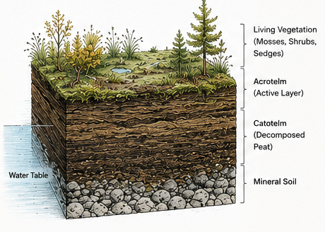
The active surface layer and permanently saturated catotelm are different physical environments. Monitoring must distinguish the water table from the deeper carbon-bearing peat profile.
Capture
Plants draw CO₂ from the atmosphere through photosynthesis.
Slow decay
Persistent saturation restricts oxygen and slows microbial decomposition.
Accumulate
Partly decomposed organic matter builds as peat, retaining carbon below the surface.
THE SCALE OF THE STORE
Most peatland carbon
is stored below ground.
Global estimates place approximately 550 gigatonnes of carbon in peatlands. UNEP describes this as roughly twice the carbon stored in the world's forests, despite peatlands occupying only about three percent of land.
≈550
Long-accumulated organic carbon held predominantly in waterlogged soils.
≈275*
Shown as the approximate implied comparison behind UNEP's “twice as much” statement.
Photosynthesis moves atmospheric CO₂ into plant tissue.
Saturation limits oxygen and slows decomposition.
Partially decomposed matter accumulates layer by layer.
Oxygen exposure can restart decomposition and release CO₂.
*Rounded, explanatory comparison—not an independent forest-stock estimate. Values vary by dataset, definition and date.
SOURCE · UN ENVIRONMENT PROGRAMMEWHY PEATLANDS FIT THIS PROJECT
Why Carbon2Green
is working with peatlands.
The chart summarizes seven characteristics of the proposed HSP project, including its location, restoration approach, measurement plan, ability to scale and ecological value.
CARBON2GREEN / HSP PEATLAND
01 / RESTORATION APPROACH
No new industrial process is required.
The project relies on established peatland restoration methods, field work and ecological recovery rather than a first-of-kind industrial plant.
02 / PROJECT LOCATION
The project is in Québec.
Québec offers airlines and investors a familiar legal and institutional setting, subject to final confirmation of project rights and authorization.
03 / MEASUREMENT
Several types of evidence can be combined.
Water levels, greenhouse-gas flux, peat, vegetation and geospatial data can be brought together in one auditable project record.
04 / LONG-TERM MANAGEMENT
Changes in the peatland can be monitored.
Water levels, vegetation and disturbance can be observed over time so that the project can respond when conditions change.
Illustrative Carbon2Green development profile, not a verified project rating. Scores express intended strengths on a common five-point scale and remain subject to rights, field performance, validation, issuance and CORSIA eligibility.
WHEN WATER LEAVES
When peat dries, it begins to release carbon.
Lowering the water table exposes peat to oxygen. Decomposition accelerates, the surface can subside, fire risk can rise and carbon accumulated over long periods can return to the atmosphere.
Water near surface
Peat remains predominantly saturated. Ecological function and hydrological connectivity are maintained.
Water table lowered
Oxygen enters the peat profile. Oxidation, subsidence and vegetation change can follow.
RESTORATION LOGIC
Restoration starts
by bringing water back.
The work is site-specific. It may involve blocking drains, installing bunds or control structures, reducing leakage, reshaping eroded channels and supporting peat-forming vegetation. The design follows the terrain and measured water movement.
- 01DiagnoseMap drainage, microtopography, peat depth, vegetation, rights and reference conditions.
- 02DesignSet hydrological objectives and model how water will move under seasonal conditions.
- 03RewetBlock or control artificial outflows with structures appropriate to the terrain.
- 04RecoverSupport vegetation and manage disturbance where passive recovery is insufficient.
- 05MeasureTrack water, vegetation, CO₂, CH₄, leakage and uncertainty over time.